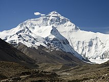
tóng-àn:Everest North Face toward Base Camp Tibet Luca Galuzzi 2006.jpg
Guā-māu

Seng khoàⁿ chiàm-liōng: 800 × 533 siōng-sò͘. Kî-thaⁿ--ê kái-sek-tō͘: 320 × 213 siōng-sò͘ | 640 × 427 siōng-sò͘ | 1,024 × 682 siōng-sò͘ | 1,280 × 853 siōng-sò͘ | 2,000 × 1,333 siōng-sò͘.
Guân-pún ê tóng-àn (2,000 × 1,333 siōng-sò͘ , tóng-àn chiàm-liōng: 883 KB, MIME luī-hêng: image/jpeg)
Tóng-àn ê le̍k-sú
Chhi̍h ji̍t-kî/sî-kan, khoàⁿ hit sî-chūn--ê tóng-àn.
| Ji̍t-kî/Sî-kan | Suè-tiunn-tôo | Tshùn-tshioh | Iōng-chiá | soat-bêng | |
|---|---|---|---|---|---|
| hiān-chāi | 2007-nî 3-goe̍h 20-ji̍t (pài-jī) 00:47 |  | 2,000 × 1,333(883 KB) | Lucag | {{Information |Description={{en|Mount Everest North Face as seen from the path to the base camp, Tibet.}} {{it|Faccia Nord del monte Everest vista dal sentiero che porta al campo base in Tibet.}} |Source=Photo taken by (Luca Galuzzi) * http |
Tóng-àn sù-iōng ê chōng-hòng
ē-kha ê ia̍h ū iōng tio̍h chit ê iáⁿ-siōng:
tóng-àn hō͘ lâng sái--ê chōng-hóng
Ē-kha--ê kî-thaⁿ wiki ēng tio̍h chit--ê tóng-àn:
- af.wikipedia.org hō͘ lâng ēng--ê chêng-hêng
- als.wikipedia.org hō͘ lâng ēng--ê chêng-hêng
- ar.wikipedia.org hō͘ lâng ēng--ê chêng-hêng
- بوابة:آسيا
- بوابة:آسيا/صورة مختارة
- ويكيبيديا:صور مختارة/أماكن/مناظر طبيعية
- قائمة أعلى القمم الجبلية في العالم
- جبال ارتفاعها أكثر من 8000 متر
- بوابة:جبال
- بوابة:جبال/صورة مختارة/أرشيف
- بوابة:جبال/صورة مختارة
- بوابة:جبال/مقالة مختارة/أرشيف
- بوابة:جبال/مقالة مختارة/4
- بوابة:جبال/صورة مختارة/8
- مستخدم:ASammour/صور مختارة
- بوابة:آسيا/صورة مختارة/11
- مستخدم:سارة عمران العبادية/ملعب
- ويكيبيديا:لا تتوقع أي شكر
- ast.wikipedia.org hō͘ lâng ēng--ê chêng-hêng
- az.wikipedia.org hō͘ lâng ēng--ê chêng-hêng
- ban.wikipedia.org hō͘ lâng ēng--ê chêng-hêng
- ba.wikipedia.org hō͘ lâng ēng--ê chêng-hêng
- bcl.wikipedia.org hō͘ lâng ēng--ê chêng-hêng
- bg.wikipedia.org hō͘ lâng ēng--ê chêng-hêng
- bn.wikipedia.org hō͘ lâng ēng--ê chêng-hêng
- bo.wikipedia.org hō͘ lâng ēng--ê chêng-hêng
- br.wikipedia.org hō͘ lâng ēng--ê chêng-hêng
- bs.wikipedia.org hō͘ lâng ēng--ê chêng-hêng
- ca.wikipedia.org hō͘ lâng ēng--ê chêng-hêng
- ceb.wikipedia.org hō͘ lâng ēng--ê chêng-hêng
- ckb.wikipedia.org hō͘ lâng ēng--ê chêng-hêng
Khuànn tsit-ê tóng-àn ê koh-khah-tsuē tsuân-i̍k sú-iōng.


